Showing posts with label 10 miles. Show all posts

Wednesday, 22 June 2016

Lake District 13th June to 14th June 2016

Lake District Tuesday14th June 2016


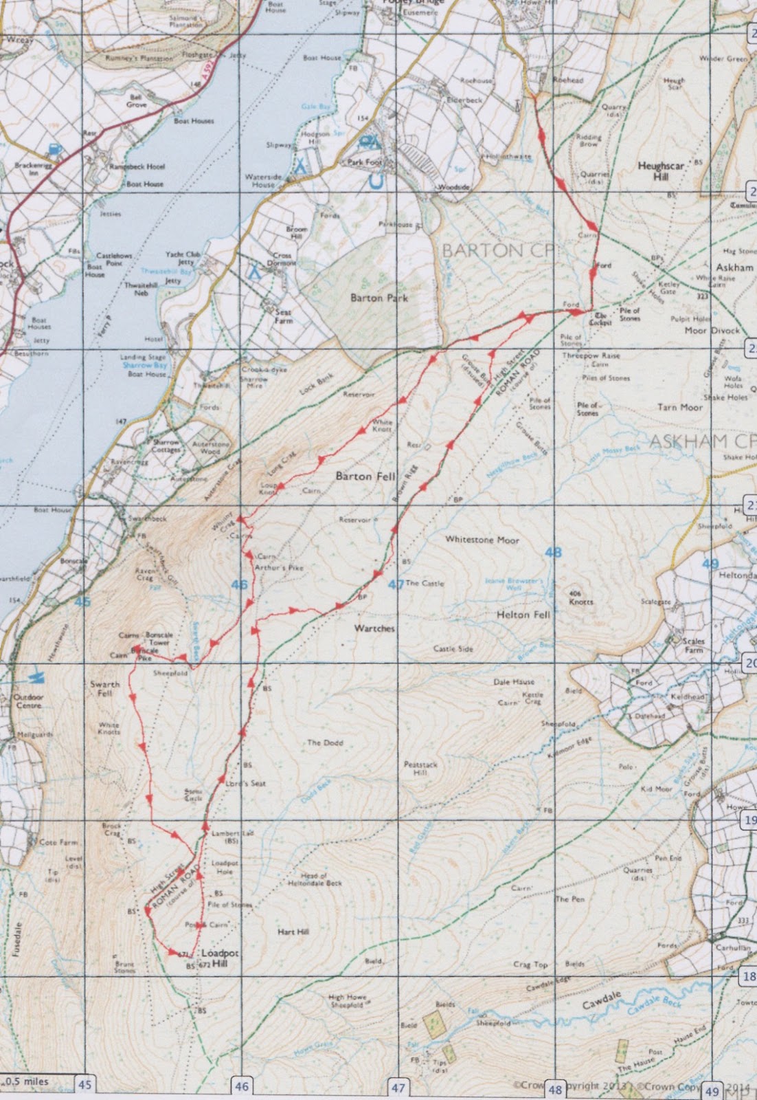
Pooley Bridge-Arthurs Pike-Bonscale Pike-Loadpot Hill
(9.8 Miles, 6 Hours)

After a showery Monday the weather improved again for a longer fell walk on Tuesday.
We had seen the ability to park cars at Roehead about a mile uphill from Pooley Bridge, and this would save us 2 miles on a 3 Wainwright trek of Arthurs Pike, Bonscale Pike and Loadpot Hill.


The route took us up the same track we had come down on our previous walk and up to the path interchange at the Cockpit. Here we headed off right away from the High Street path and towards our 1st Wainwright summit of Arthurs Pike.


Views from the lower track along Ullswater and the ferry coming into Pooley Bridge.


Lovely easy grassy paths and fantastic views and the day stayed dry. Perfect walking weather.


First Wainwright of Arthurs Pike (1745ft) and stopped to admire the wonderful lake views.


The view across to Hallin Fell, no low mist today.


The view ahead to our next waypoint in the foreground and Helvellyn in the far distance.


After an easy slight down off Arthurs Pike and an easy up to Bonscale Pike (1719ft) we arrived at the 2nd Wainwright and took a long lunch stop. The view here was even better and most of Ullswater could be seen.


Coming down off Bonscale Pike was easy, but it was a fair trek over to Loadpot Hill, eventually rounding the bottom of it along grassy tracks before a steeper pull over the top.


Not so great views at the top of Loadpot Hill (2201ft), but the 3rd Wainwright, we did not stop for too long and carried on straight over pausing just for a picture and drink stop.


From here the way back linked to the main High Street path after coming down off Loadpot Hill and a long, but easy trek back  the start, joining the path down to Roehead at the Cockpit once again.

A fantastic walk with no technical difficulties and really brilliant lake views. Highly recommended as al longer but easy walk.


Our Walk Score: 8/10

Sunday, 2 November 2014

Peak District - Derwent Edge 28th October 2014

Peak District - Derwent Edge 28th October 2014

Lost Lad - 10 Miles, 5.5hrs

A rather sunny end of October day, and an ideal chance for a Peak District walk.
We had been at a concert at Sheffield Arena (rock band Black Stone Cherry), the night before and stayed over in Sheffield.

We had done "Lost Lad" a few years ago and enjoyed the walk so thought it would make a good jaunt amongst the Autumn leaves along the reservoir mixed with some height and longer views.


We parked by the side of the road just up from the main Fairholmes car park, so parked for free. It was then just a short 5 mins or so to Fairholmes and only another few minutes then to the start point at the Derwent dam.


The Autumnal trees were impressive with the light catching them on such a pleasant day.


Heading up a track, through the trees you can see above, took us to the main wide track running alongside the Derwent reservoir. It was then an enjoyable and flat stroll for about two miles along this.


We headed right off the track at Abbey Bank, quite steeply zig-zagging back, and then across to give the view down to the reservoir.


We then headed away from the reservoir and across more open moorland.


Eventually meeting more rockier, rugged, grit-stone terrain, and the rather unique rock formations and "Lost Lad." The hill of Lost Lad gets its name and its impressive cairn from a story of a shepherd boy who got lost and lost his life on the moors in a severe blizzard. It wasn't until the spring that another shepherd passing by found the lost shepherd's body and by it written on a rock were the words "Lost Lad".


The high summit of Back Tor has some very impressive grit stone formations.


The views from Back Tor are quite unusual, there aren't many places in the Peak you can see so many of its highest features. The Great Ridge, Derwent Valley Reservoirs, Stanage Edge, Bleaklow and Kinder Plateau can all be seen from this viewpoint.


Passing various rock formations with names such as "Cakes of Bread", "Salt Cellar" all adds interest to this walk, before a relatively easy descent down after about three miles walking along the ridge.


Ladybower reservoir seen on descent


Nice path.


Then an easy walk back along the edge of the reservoir to the car park about another three miles.


A fairly long walk altogether, though not too taxing from an ascent/desent point of view, with great views and interesting rock formations.

A cup of soup at the car park facilities, and then home at 15:30 as it's starting to get dusky pretty soon now at this time of year.

roll on spring 2015!

Our Walk Score: 7.5/10